Walking the Yorkshire coast
From the Humber to the Tees
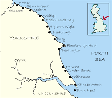
Walking the Yorkshire coast from the Humber to the Tees
Is it possible?
There isn’t yet an officially designated walk over the full uninterrupted length (although the Cleveland Way/ King Charles III England Coast Path follows part of it) so I set myself the challenge of finding a route between the Humber and the Tees following cliff paths and beaches. Dividing it up into manageable sections, totalling approximately 124 miles, the aim being to make it a series of enjoyable walks rather than an arduous route march such that, when completed, it would give me the satisfaction of saying, ‘I have walked the Yorkshire coast’.

I feel a walking holiday would be a tremendous way of undertaking the walk or parts of it. Needless to say, there is plenty of accommodation along the way.
Footpaths were identified by reference to Ordnance Survey maps which are available as overlays on bing.com/maps and distances were calculated using gb.mapometer.com. Navigation is not difficult although part of the footpath around Scarborough has been lost to erosion and an ad hoc diversion had to be found using a bit of common sense!
Click on the map or menu for further details of individual walks and photos of my journey.
(All the photos are mine so please contact me if you want to reproduce any - thanks)